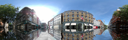
In light of the previous post on flooding London we looked into the ability to visualise flooding levels in a panoramic image. There are various problems involved including making sure the warping of the flood detail in photoshop matches the photograph. Some seams are noticeable but it still gives the illusion of street flooding.
View the Quicktime panorama of Charlotte Street, London, Flooded(1.9mb).
Flooding London Panorama
Andy
CASA, UCL East
Recent
The Papers: The 2nd Album
Spatial Computing and the Phygital City: Towards Digital Habitation
Color Weather: A Data Watch Face for the Pebble Time 2
Fenland: A weeWX Dashboard with forecast verification, ensemble models, climate records back to 1940 and finally, that tween...
City Clock: A City where the People Tell the Time