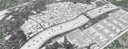
Adding to our first post on London in 1690 in Google Earth using image overlays we are now publishing London in 1666. The above image illustrates the layout of London in 1666 by Wenceslaus Hollar.
Hollar was appointed by the King to make exact plan and survey of the City after the Fire on London in September 1666. The fire destroyed 373 acres inside the city walls and 63 acres outside, 87 churches destroyed (including St. Paul's Cathedral) and 13,200 houses.
Aligning historic maps is notoriously difficult - here we have aligned the road network and the north bank of the river to provide a overview of the City as viewed by Hollar.
You can download the kml file to fly into the overlay in Google Earth here
London Google Earth 1666
Andy
CASA, UCL East
Recent
The Papers: The 2nd Album
Spatial Computing and the Phygital City: Towards Digital Habitation
Color Weather: A Data Watch Face for the Pebble Time 2
Fenland: A weeWX Dashboard with forecast verification, ensemble models, climate records back to 1940 and finally, that tween...
City Clock: A City where the People Tell the Time